
About

Geomatics Engineer | GIS Specialist
A Geomatics Engineer with an expertise in GIS, remote sensing, and spatial data analysis, holding a Bachelor degree in Geomatics Engineering from Kathmandu University. Experienced in projects related to Coral Reef Monitoring, Agroforestry research, WASH systems, and WebGIS development. Passionate about applying geospatial technologies for climate resilience, open mapping, and community-focused solutions.
- Name: Rabina Poudyal
- Degree: Bachelor in Geomatics Engineering
- Address: Palpa, Nepal
- Email: [email protected]
- Birthday: 8th March, 2002
Paper Published
Projects Completed
Awards Won
Years of Experience
Education / Experience
Education
Bachelor in Geomatics Engineering
Kathmandu University
2019-2024
- CGPA: 3.59/4.00
High School Education
New Summit College
2017-2019
- CGPA: ***
Secondary Level Education
Prasadi Secondary School
2007-2017
- CGPA: ***
Professional Experience
GIS Engineer
Kathmandu Metropolitan City
Jan 2025 - Jul 2025
- Working in "Road Naming and Mapping Project" under Kathmandu Metropolitan City.
- Develop WebGIS Portal and GIS Platfrom.
- Supervised Junior Surveyors and conducted the Road Survey.
Geoamtics Engineer
Genesis Consultancy Pvt Ltd.
Aug 2024 - Jan 2025
- Worked in WASH (Water Sanitation and Hygiene) Project that includes the Spatial and Non-spatial Data Analysis.
- Worked in WebGIS Development Project and Spatial Database Management (PHP and SQL)
- Created detailed maps and visualizations.
Geospatial Data Analyst Intern
Kathmandu Living Labs
March 2024 - May 2024
- Worked on Cartography Section. Designed Light Map Style for "Baato" Apps.
- Make an location based spatial analysis for EV Station in Nepal
Skills
Project / Research
Services
Geospatial Analysis
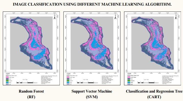
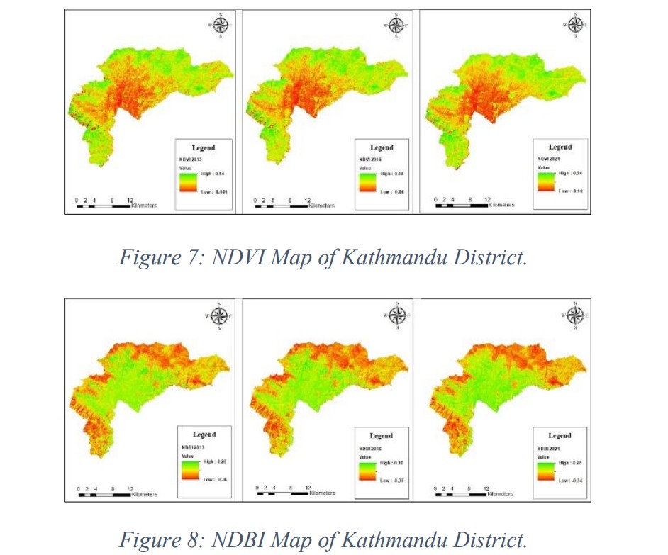
I offer geospatial analysis services using Remote Sensing, Google Earth Engine, and various machine learning algorithms for data processing and decision-making. From land use classification to environmental monitoring, I can analyze spatial data to derive meaningful insights for research and project applications.
Web-GIS Design
Specialized in WebGIS design, creating interactive web maps for diverse applications. With experience in earthquake visualization, Integrated Municipal Systems, and the KMC Web Portal using Leaflet and other tools, I can develop user-friendly and efficient geospatial solutions tailored to project needs.
Field Survey
Experienced in conducting field surveys using advanced equipment such as Total Station, Drone, DGPS, LiDAR, and Plane Table, and many more. I provide precise data collection and mapping services for various projects, ensuring accuracy and efficiency in geospatial analysis.
GIS Mapping
I provide GIS mapping services for spatial data visualization, analysis, and decision-making. With expertise in creating detailed maps using satellite imagery, field data, and geospatial techniques, I develop accurate and interactive mapping solutions for various applications.
Land Measurement
I provide land measurement services, including precise area calculations, staking out points or plots, and parcel division. Using advanced surveying techniques and equipment, I ensure accurate boundary determination and land mapping for property management, construction, and development projects.
Content Writing
I offer content writing services, creating clear, engaging, and well-researched content tailored to various needs. With experience in technical writing, articles, reports, and web content, I ensure informative and compelling communication for different audiences.
Testimonials
Write things up here.

Er. Ashok Shrestha
Kathmandu Metropolitan City
Survey Officer
Write things up here.
Er. Shreeda Ram Prajapati
Genesis Consultancy Pvt Ltd.
Managing Director
Write things up here.

Er. Sushma Ghimire
Kathmandu Living Labs
GIS Data Analyst
Contact
Address:
Palpa, Nepal